Michalova Deposit
Near Brezno, central Slovakia — Shallow geometry, full existing infrastructure, and waste dump grades exceeding 30% MnO.
Shallow Geometry, Strong Infrastructure
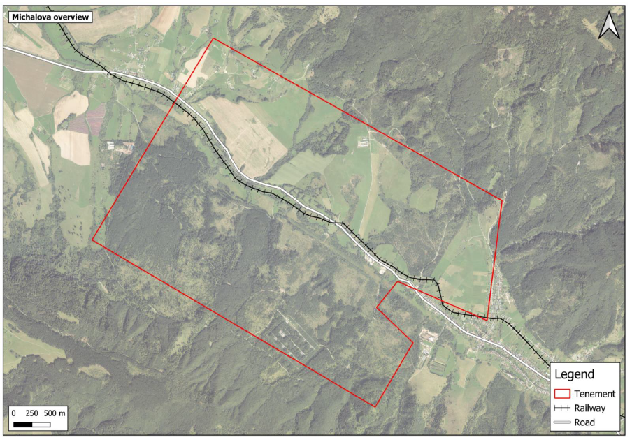
The Michalova manganese deposit is located near the town of Brezno in central Slovakia. The deposit features a shallow oxide ore seam included in the historic estimate, plus a deeper carbonate ore layer 5–30 m thick that was largely excluded from historical calculations — representing significant expansion potential.
Waste dump sampling has returned grades exceeding 30% MnO, indicating that even discarded material from historic mining operations contains substantial manganese content. The deposit's gently dipping flatbed geometry within the Breznianska Basin makes it amenable to conventional, cost-effective mining methods.
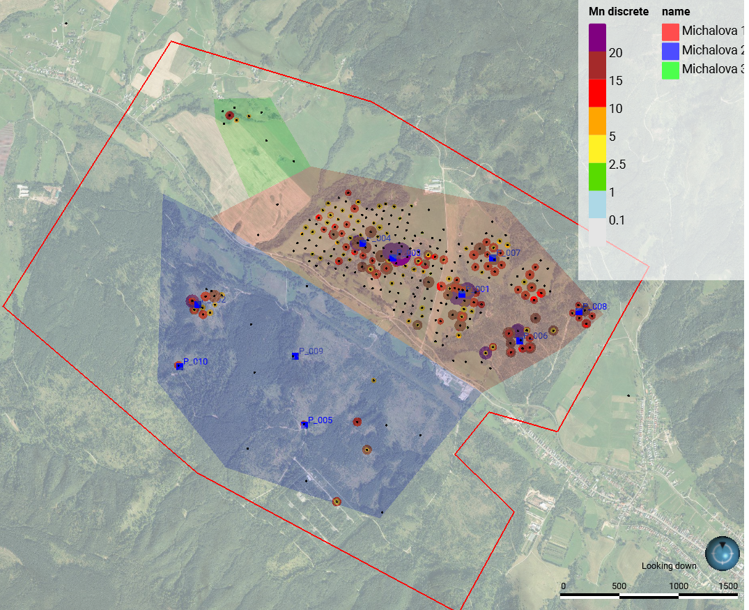
The historic resource totals 10,406,260 tonnes at an average grade of 9.49% Mn, classified under the GKZ system across three resource blocks (M-1, M-2, and M-3).
- Location
- Near Brezno, Banská Bystrica Region, central Slovakia
- Ore Types
- Shallow oxide ore seam (in estimate) + deeper carbonate ore layer 5–30 m thick (largely excluded)
- Geological Setting
- Breznianska Basin — gently dipping flatbed, Paleogene sediments to ~500 m depth
- Key Advantage
- Shallow depth, full infrastructure (rail, road, power), favorable municipality, waste dump >30% MnO
Resource Blocks
Three resource blocks classified under the GKZ system (1993).
| Block | Tonnes | Grade (%Mn) |
|---|---|---|
| Block M-1 | 813,082 | 9.49% avg |
| Block M-2 | 9,586,655 | 9.49% avg |
| Block M-3 | 6,523 | 9.49% avg |
| TOTAL | 10,406,260 | 9.49% Mn |
*GKZ classification (1993). NOT NI 43-101 compliant. Deeper carbonate layer (5–30 m thick) largely excluded — significant expansion potential.
Existing Infrastructure
The Michalova licence area benefits from full existing infrastructure, significantly reducing future development capital requirements.
Railway
Single railway line passes directly through the licence area
Asphalt Road
Double-lane asphalt road passes through the licence area
22 kV Power
22 kV power lines within the licence area
Municipal Support
Local municipality favorable to exploration activities
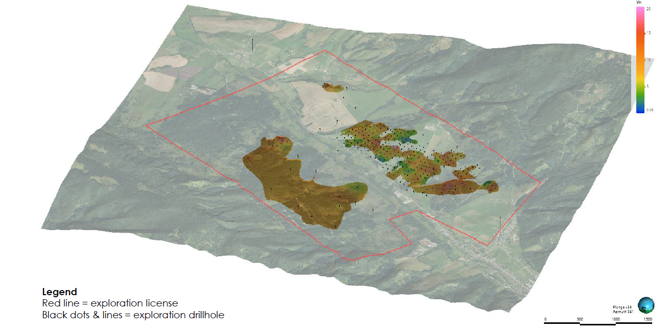
Geological Setting & Growth Potential
Ore Types & Geometry
- Shallow Oxide Ore
- Included in the historic 10.4 Mt estimate. Oxide seam at shallow depth, accessible by conventional mining methods within the Breznianska Basin.
- Deep Carbonate Layer
- A 5–30 m thick carbonate ore seam sits beneath the oxide. Largely excluded from the historic estimate — this represents the primary expansion opportunity.
- Basin Structure
- Gently dipping flatbed — Breznianska Basin, Paleogene sediments extending to ~500 m depth. Favorable geometry for systematic extraction.
Expansion Potential
- Block M-2 Upside
- Block M-2, which accounts for 92% of the total resource (9.59 Mt), has only limited historical drill testing. Significant room for resource upgrade with modern drilling.
- Deep Carbonate Excluded
- The entire deep carbonate seam (5–30 m thick) was excluded from the 1993 GKZ estimate. Including this layer could materially increase the resource base.
- Regional Prospectivity
- NW and SE areas within the licence are prospective per Hutianske Formation outcrops. Additional exploration targets identified but untested.
Michalova Licence & Infrastructure
Historic drill hole distribution, regional infrastructure context, and 3D geological interpretation of the Michalova deposit.
Planned Drilling Program
A confirmatory drilling program is planned for Q2 2026 at Michalova to twin historical drill holes and collect metallurgical samples.
Target Start
Confirmatory drilling program designed to twin historical holes and validate GKZ-era data with modern core samples.
Drilling Method
Diamond core drilling to provide high-quality subsurface samples for geological and metallurgical analysis.
Metallurgical Samples
Samples to be collected for laboratory testing to evaluate processing characteristics and support future NI 43-101 reporting.
Explore Further
Learn about the EU policy driving domestic manganese demand, or explore how to participate in Union Power Metals's growth story.